

|

|

|

|

|

|

|

|

|

|
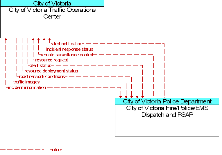
Interface: City of Victoria Fire/Police/EMS Dispatch and PSAP To City of Victoria Traffic Operations Center |
 |
Architecture Flow Definitions
alert notification
(Future)
![]()
Notification of a major emergency such as a natural or man-made disaster, civil emergency, or child abduction for distribution to the public. The flow identifies the alert originator, the nature of the emergency, the geographic area affected by the emergency, the effective time period, and information and instructions necessary for the public to respond to the alert. This flow may also identify specific information that should not be released to the public.
alert status
(Future)
![]()
Information indicating the current status of the emergency alert including identification of the traveler and driver information systems that are being used to provide the alert.
incident information
(Future)
![]()
Notification of existence of incident and expected severity, location, time and nature of incident. As additional information is gathered and the incident evolves, updated incident information is provided. Incidents include any event that impacts transportation system operation ranging from routine incidents (e.g., disabled vehicle at the side of the road) through large-scale natural or human-caused disasters that involve loss of life, injuries, extensive property damage, and multi-jurisdictional response.
incident response status
(Future)
![]()
Status of the current incident response including a summary of incident status and its impact on the transportation system, traffic management strategies implemented at the site (e.g., closures, diversions, traffic signal control overrides), and current and planned response activities.
remote surveillance control
(Future)
![]()
The control commands used to remotely operate another center's sensors or surveillance equipment so that roadside surveillance assets can be shared by more than one agency.
resource deployment status
(Future)
![]()
Status of traffic management resource deployment identifying the resources (vehicles, equipment, materials, and personnel) available and their current status. General resource inventory information and specific status of deployed resources may be included.
resource request
(Future)
![]()
A request for traffic management resources to implement special traffic control measures, assist in clean up, verify an incident, etc. The request may poll for resource availability or request pre-staging, staging, or immediate deployment of resources.
road network conditions
(Future)
![]()
Current and forecasted traffic information, road and weather conditions, traffic incident information, and other road network status. Either raw data, processed data, or some combination of both may be provided by this architecture flow. Information on diversions and alternate routes, closures, and special traffic restrictions (lane/shoulder use, weight restrictions, width restrictions, HOV requirements) in effect is also included.
traffic images
(Future)
![]()
High fidelity, real-time traffic images suitable for surveillance monitoring by the operator or for use in machine vision applications. This flow includes the images and the operational status of the surveillance system.
 Web Spinner Technology.