

|

|

|

|

|

|

|

|

|

|
![]()

|
 |
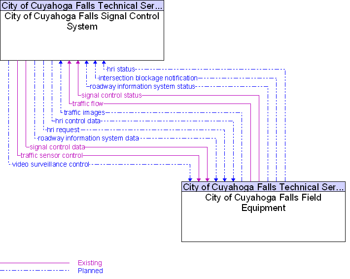
Interface: City of Cuyahoga Falls Field Equipment To City of Cuyahoga Falls Signal Control System |
Architecture Flow Definitions
hri control data
(Planned)
![]()
Data required for HRI information transmitted at railroad grade crossings and within railroad operations.
hri request
(Planned)
![]()
A request for highway-rail intersection status or a specific control request intended to modify HRI operation.
hri status
(Planned)
![]()
Status of the highway-rail intersection equipment including both the current state or mode of operation and the current equipment condition.
intersection blockage notification
(Planned)
![]()
Notification that a highway-rail intersection is obstructed and supporting information.
roadway information system data
(Planned)
![]()
Information used to initialize, configure, and control roadside systems that provide driver information (e.g., dynamic message signs, highway advisory radio, beacon systems). This flow can provide message content and delivery attributes, local message store maintenance requests, control mode commands, status queries, and all other commands and associated parameters that support remote management of these systems.
roadway information system status
(Planned)
![]()
Current operating status of dynamic message signs, highway advisory radios, beacon systems, or other configurable field equipment that provides dynamic information to the driver.
signal control data
(Existing)
![]()
Information used to configure and control traffic signal systems.
signal control status
(Existing)
![]()
Status of surface street signal controls.
traffic flow
(Existing)
![]()
Raw and/or processed traffic detector data which allows derivation of traffic flow variables (e.g., speed, volume, and density measures) and associated information (e.g., congestion, potential incidents).
traffic images
(Planned)
![]()
High fidelity, real-time traffic images suitable for surveillance monitoring by the operator or for use in machine vision applications. This flow includes the images and the operational status of the surveillance system.
traffic sensor control
(Existing)
![]()
Information used to configure and control traffic sensor systems.
video surveillance control
(Planned)
![]()
Information used to configure and control video surveillance systems.
 Web Spinner Technology.