

|

|

|

|

|

|

|

|

|

|
![]()

|
 |
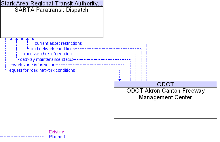
Interface: ODOT Akron Canton Freeway Management Center To SARTA Paratransit Dispatch |
Architecture Flow Definitions
current asset restrictions
(Planned)
![]()
Restrictions levied on transportation asset usage based on infrastructure design, surveys, tests, or analyses. This includes standard facility design height, width, and weight restrictions, special restrictions such as spring weight restrictions, and temporary facility restrictions that are imposed during maintenance and construction.
request for road network conditions
(Planned)
![]()
Request for traffic information, road conditions, surface weather conditions, incident information, and other road network status. The request specifies the region/route of interest, the desired effective time period, and other parameters that allow preparation of a tailored response. The request can be a subscription that initiates as-needed information updates as well as a one-time request for information.
road network conditions
(Planned)
![]()
Current and forecasted traffic information, road and weather conditions, incident information, and other road network status. Either raw data, processed data, or some combination of both may be provided by this architecture flow.
road weather information
(Planned)
![]()
Road conditions and weather information that are made available by road maintenance operations to other transportation system operators.
roadway maintenance status
(Planned)
![]()
Summary of maintenance fleet operations affecting the road network. This includes the status of winter maintenance (snow plow schedule and current status).
work zone information
(Planned)
![]()
Summary of maintenance and construction work zone activities affecting the road network including the nature of the maintenance or construction activity, location, impact to the roadway, expected time(s) and duration of impact, anticipated delays, alternate routes, and suggested speed limits. This information may be augmented with images that provide a visual indication of current work zone status and traffic impacts.
 Web Spinner Technology.